


Le plan du qx10

melsacri
User
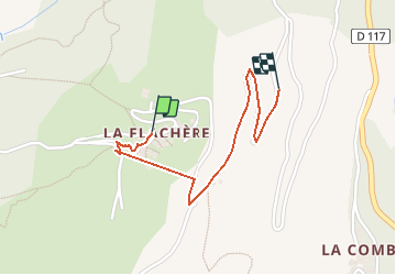

Length
1.4 km

Max alt
1393 m

Uphill gradient
12 m
Km-Effort
2.1 km

Min alt
1232 m

Downhill gradient
150 m
Boucle
No
Creation date :
2021-02-14 10:56:00.833
Updated on :
2021-02-14 13:55:03.359
11m
Difficulty : Very easy

FREE GPS app for hiking
 SityTrail
IGN / Geographical institutes
SityTrail Plus
The world is yours!
About
Trail Touring skiing of 1.4 km to be discovered at Auvergne-Rhône-Alpes, Savoy, Les Belleville. This trail is proposed by melsacri.
Positioning
Country:
France
Region :
Auvergne-Rhône-Alpes
Department/Province :
Savoy
Municipality :
Les Belleville
Location:
Saint-Jean-de-Belleville
Start:(Dec)
Start:(UTM)
302744 ; 5032055 (32T) N.
Comments